2.0 SUMMARY OF EXISTING CONDITIONS
2.1 PRIORITY LAKE AND WATERSHED MANAGEMENT ISSUES
Early in the planning process, the Lake Tarpon Management Committee (LTMC) identified a number of priority lake and watershed management issues. Although the primary initial concern necessitating their mission was water quality degradation, it was recognized that the lake and its watershed must be viewed as a holistic ecosystem, and managed accordingly. As such, it was concluded that no consensus would ever be reached with regard to the development of a management strategy unless the interrelationships between water quality, living resources, and human beneficial uses of the lake were all considered and balanced appropriately.
A total of seven priority lake and watershed management issues were identified by the LTMC. A brief summary of the problem statement associated with each priority issue is provided below.
Issue #1 - Water Quality: Available monitoring data indicate that water quality, as measured by chlorophyll-a and nutrient concentrations, is declining in Lake Tarpon. There is a justifiable concern that the trophic state of Lake Tarpon is advancing to a level where other adverse ecological changes could soon follow (see Section 2.2 below for a more detailed discussion of trophic state changes). Conversely, no significant public health related water quality problems (e.g., high concentrations of toxics or pathogens) have been observed in Lake Tarpon.
Issue #2 - Aquatic Vegetation: Available assessment data indicate that the diversity of emergent aquatic vegetation has declined significantly in the last 25 years with the implementation of a water level control schedule, and the resulting proliferation of monotypic stands of cattail dominating the shoreline of the lake. Cattails obstruct waterfront views and shoreline access, and provide poorer fish and wildlife habitat than other more desirable vegetation. In addition, keeping the coverage of nuisance submerged aquatic vegetation such as hydrilla in check presents a continuous management challenge. Large scale chemical treatments of hydrilla in Lake Tarpon have been correlated with degraded water quality, probably due to the release of nutrients into the water column from the decomposition of excessive hydrilla plant tissue.
Issue #3 - Fisheries: Lake Tarpon is one of the foremost sport fishing lakes in Florida. The largemouth bass and panfish fisheries are considered to be healthy, however, more recent assessment data indicate that fish biomass in Lake Tarpon increased substantially during the early 1990s. Although the lack of hydrilla control during 1991-1992 may have contributed to several exceptionally strong year classes in subsequent years, there is a justifiable concern that the recent rise in fish biomass is an indicator of increasing eutrophication which, if continued unchecked, could threaten the integrity of the sport fisheries in Lake Tarpon.
Issue #4 - Wildlife and Associated Habitat: Land development in the Lake Tarpon watershed has resulted in the loss of hundreds of acres of natural habitats and their associated wildlife populations. Although existing wetlands in the basin are well protected under federal and state laws, measures to protect remaining upland habitats are needed. Furthermore, urban wildlife management programs and techniques such as golf course and residential habitat enhancement could improve wildlife utilization of the basin.
Issue #5 - Flood Control: The construction of the Lake Tarpon outfall canal and water level control structure in the 1970s effectively addressed the severe flooding problems that existed in the basin prior to these actions. The primary concern with regard to the flood control issue in the Lake Tarpon basin is that the level of flood protection currently provided by the outfall canal and structure not be significantly compromised to accommodate the attainment of other lake management goals.
Issue #6 - Recreation and Aesthetics: Lake Tarpon is an important economic resource to Pinellas County and the City of Tarpon Springs due to the recreational aesthetic benefits it provides. Recreational benefits include sport fishing, boating (including personal watercraft), water skiing, and more passive uses such as canoeing and bird watching. User surveys performed by the County indicate that a high proportion of recreational boaters and skiers are attracted from neighboring counties, whereas sport fishermen are attracted from all of Florida and neighboring states. These surveys also indicate that conflicts exist between certain user groups, primarily motorcraft users (e.g., water skiers and personal watercraft users) and fishermen, who often pursue incompatible recreational activities in the same areas at the same time. As a result, the quality of the recreation experience, and possibly public safety, has been compromised. In addition, the highly attractive aesthetic environment provided by the lake adds considerable value to waterfront and nearby residential properties. There is a justifiable concern that unresolved user conflicts and degrading ecological conditions could adversely impact the socioeconomic benefits provided by Lake Tarpon.
Issue #7 - Public Education: Residential surveys of people living in the Lake Tarpon basin indicate that the general population is generally not knowledgeable regarding lake and watershed management issues. However, these same surveys indicate that many residents are interested in helping to monitor and improve environmental conditions in the lake and watershed. A need exists to better inform the public of issues facing Lake Tarpon and to solicit public support and volunteerism in the implementation of the Plan.
The following sections provide a summary of the existing conditions with regard to each of the identified priority lake and watershed management issues.
As discussed in Section 1.1 above, a major algae bloom in the spring and summer of 1987 precipitated public and scientific concern about the ecological status of Lake Tarpon. This algae bloom was seen as an indication that the trophic state of the lake was increasing. The term trophic state can be loosely defined as the nutritional status of a lake. Like other plants, microscopic, single-celled algae, also referred to as phytoplankton, require nitrogen and phosphorus and primary nutrients to grow and reproduce. In lakes and other waterbodies, however, if nutrients are available in the water column in concentrations that are too high, nuisance algae blooms occur.
If these conditions persist for a prolonged period of time, many ecological changes begin to take place in the lake. First, the excessive algae concentrations increase turbidity in the water column and shade out the light that supports rooted plants, eventually resulting in the die-off of submerged aquatic vegetation. Second, the bacterial breakdown of the excessive amount of dead algal cells raining down on the lake bottom results in a depletion of oxygen in the water column which can result in fish kills. Third, when algae becomes the dominant source of primary production (photosynthesis) in the lake, this can result in a shift in the fish population structure from a predominance of carnivorous sport fish (e.g., largemouth bass) to a predominance of herbivorous rough fish (e.g., gizzard shad). This process is called eutrophication.
Lake eutrophication is a natural process resulting from the gradual accumulation of nutrients, increased productivity, and a slow filling in of the basin with accumulated sediments, silt and organic matter from the watershed. The classical lake succession sequence is usually depicted as a unidirectional progression through the following series of phases or trophic states:
Oligotrophy - nutrient-poor, biologically unproductive, low turbidity.
Mesotrophy - intermediate nutrients and biological productivity, moderate turbidity.
Eutrophy - nutrient-rich, high biological productivity, high turbidity.
Hypereutrophy - pea soup conditions, the extreme end of the trophic continuum.
Although natural eutrophication could take tens of thousands of years to occur, a lake’s lifespan can be drastically shortened by human-induced cultural eutrophication. Activities in the watershed such as forest clearing, road building, agricultural cultivation, residential and commercial development, stormwater runoff and wastewater discharges can all result in substantial increases in the discharge of nutrients, organic matter and sediments to the lake. Figure 2-1 illustrates the differences between natural and cultural eutrophication.
Figure 2-1. Natural eutrophication versus man-induced eutrophication.
As stated in Section 2.1 above, the primary concern with regard to the water quality issue in Lake Tarpon is excessive cultural eutrophication. Other types of water quality problems can occur in lakes such as high concentrations of toxics (e.g., heavy metals, pesticides, etc.) and pathogens (e.g., coliform bacteria), but these types of public health problems have not been observed in Lake Tarpon to any significant degree. Rather, the major concerns are: 1) the control of excessive nutrients entering the lake; and 2) the fate of the nutrients that do reach the lake (e.g., algae blooms vs. rooted plant growth).
The primary measure of the degree of lake eutrophication is the chlorophyll-a concentration in the water column. Chlorophyll-a is an estimate of algal cell biomass, and may be directly related to the trophic state of the lake. The following summaries of the status and trends in water quality and pollutant loading sources focus primarily on the parameters of chlorophyll-a, total nitrogen (TN) and total phosphorus (TP).
The SWFWMD and Pinellas County have been monitoring water quality in Lake Tarpon since 1987. Due to inconsistencies in field sampling and laboratory analytical techniques, only chlorophyll-a and total nitrogen concentrations can be reliably used to discern multi-year temporal trends in the trophic state of the lake. Figure 2-2 shows a plot of mean annual chlorophyll-a concentrations in Lake Tarpon for the period 1988 through 1996 in relation to mean annual TN concentrations, and cumulative annual rainfall amounts. Figure 2-3 shows a plot of mean annual chlorophyll-a concentrations for the same period in relation to mean annual pH, and cumulative annual rainfall amounts. In addition, other key chronological events which have likely impacted the lake trophic state are noted. The following conclusions can be made about these plots.
Chlorophyll-a concentrations were relatively low and stable in 1988 and 1989 following the major algae bloom of 1987.
Chlorophyll-a concentrations decreased in 1990. It is hypothesized that this decrease was a lake response to the accidental release of water over the outfall structure in March of 1990, which lowered the lake levels by approximately one foot. This release of water had the effect of flushing the lake of excess nutrients, and eventually diluting the lake volume with relatively nutrient-poor rainwater. In addition, it is hypothesized that groundwater seepage from the surficial aquifer also resulted in a reduction in the lake pH which may in turn have suppressed algae growth during the summer of 1990.
Chlorophyll-a concentrations increased to pre-drawdown levels in 1991. During the summer of 1991, the pH levels in the lake returned to normal conditions.
Chlorophyll-a concentrations decreased again in 1992. Although rainfall amounts were slightly higher in 1991 and 1992, it is hypothesized that the observed reduction in chlorophyll-a was a lake response to the dramatic expansion in the coverage of hydrilla during this time period. The hydrilla expansion occurred during a hiatus in the chemical treatment of the lake by the FDEP due to funding constraints. The expansion of hydrilla across the bottom of the lake may have reduced the rate of nutrient exchange between the sediments and the water column, and the hydrilla plants and associated epiphytic algae may have been competing more effectively with phytoplankton for the available water column nutrients.
Chlorophyll-a concentrations increased substantially in 1993 and have remained relatively high since then. It should be noted that the observed chlorophyll-a increases during 1993 and 1994 occurred during a period of reduced rainfall. Therefore, increased nonpoint source loadings cannot be attributed to this trend. The most plausible explanation for this trend involves the large-scale chemical treatment of hydrilla. During late 1992 and early 1993, over 500 acres of dense hydrilla were chemically treated resulting in a major hydrilla die-off. As this dead plant biomass decomposed, the nutrients contained within the plant tissue were released into the water column, thus stimulating phytoplankton growth.
Like chlorophyll-a, TN concentrations have also increased in the lake since 1993. The cause of this increase is not known, however, the relationship of this trend to the 1993 hydrilla die-off is intuitive. It is also consistent with what has been observed in other Florida lakes where large-scale hydrilla treatment has been implemented (e.g., Lake Seminole). Although development has continued at a steady pace since 1993, especially in the East Lake area, no substantial land use changes and associated nutrient loadings have occurred in the study area during this time period to account for the observed trends.
Figures 2-4 and 2-5 show the relationship between mean annual chlorophyll-a and TN, and chlorophyll-a and pH, respectively. Both pH and TN are closely correlated with chlorophyll-a. It should be noted that while TN loads are clearly affecting chlorophyll-a concentrations, there also appears to be a direct relationship between algal productivity (as expressed by chlorophyll-a) and pH. One water quality effect of increased algal productivity is increased pH due to the removal of carbon dioxide (CO2) and the production of carbonate in the water column during active photosynthesis. While the low pH values observed in Lake Tarpon during the summer of 1990 may have been a function of reduced algal productivity, they are more likely explained by the seepage of acidic groundwater from the surficial aquifer into the lake following the accidental drawdown that occurred in March of 1990. In turn, the reduced pH may have stunted phytoplankton production during this time period, thus contributing to the observed reduction in chlorophyll-a concentrations.
Figure 2-2. Plot of mean annual chlorophyll-a concentrations against TN and rainfall.
Figure 2-3. Plot of mean annual chlorophyll-a concentrations against pH and rainfall.
Trophic State Index
Although trophic state concepts have been in existence for some time, much controversy has existed over the terminology, the precise definition of various trophic state classes, and the development of an ecologically meaningful and widely accepted quantitative procedure for determining trophic state. In general, the most widely accepted trophic state index for Florida lakes is that developed by Huber et al. (1983). This index is unique in that it was developed specifically for Florida lakes, and thus recognizes and assimilates various characteristics (e.g. well-mixed, nitrogen limiting conditions) generally not accommodated in trophic state indices developed for temperate lakes. The Florida lakes index is calculated differently for nitrogen limited, phosphorus limited, and nutrient balanced lakes; and involves the calculation of separate sub-indices for total nitrogen, total phosphorus, chlorophyll-a, and Secchi depth. The overall trophic state index (TSI) for a lake is determined by combining the appropriate sub-indices to obtain an average for the physical, chemical, and biological features of the trophic state.
To determine the current trophic state of Lake Tarpon, the most recent monitoring data available from Pinellas County, covering the period May 1996 through April 1997, were used. These most recent data corrected previous laboratory problems related to the lower detection limit which resulted in the skewing of monthly and annual TP means. The mean monthly concentrations of chlorophyll-a, TN, TP, and the mean monthly Secchi depth, for this time period are as follows:
Chlorophyll-a (Chl-a) = 23.86 ug/l
Total Nitrogen (TN) = 1.06 mg/l
Total Phosphorus (TP) = 42.0 ug/l
Secchi Depth (SD) = 1.01 m
As discussed by Huber et al. (1983), three classes of lakes can be described pursuant to the total nitrogen to total phosphorus ratio. They are as follows:
Nitrogen-limited lakes = TN/TP < 10
Nutrient-balanced lakes = 10 < TN/TP < 30
Phosphorus-limited lakes = TN/TP > 30
Using the mean values shown above, the TN:TP ratio in Lake Tarpon is 25.24, making it a nutrient-balanced lake, at least under current conditions. Therefore, the TSI for nutrient balanced lakes is appropriate, and is defined as:
TSI(AVE) = 1/3 [TSI(Chl-a) + TSI(SD) + 0.5[TSI(TPB) + TSI(TNB)]]
Where TSI(Chl-a), TSI(SD), TSI(TPB), and TSI(TNB) are sub-indices for chlorophyll-a, secchi depth, TN nutrient-balanced, and TP nutrient-balanced, respectively. These sub-indices are given and solved as follows:
TSI(Chl-a) = 16.8 + (14.4 ln Chl-a) = 62.47
TSI(SD) = 10 [6.0 - (3.0 ln SD)] = 59.70
TSI(TNB) = 10 [5.6 + (1.98 ln TN)] = 57.15
TSI(TPB) = 10 [(1.89 ln TP) - 1.84] = 52.24
With the values of all sub-indices known, TSI(AVE) for Lake Tarpon can be solved as follows:
TSI(AVE) = 1/3 [62.47 + 59.70 + 0.5 (57.15 + 52.24) = 58.96
Therefore, the calculated current trophic state index for Lake Tarpon, for the period May 1996 through April 1997 is 58.96. A primary issue regarding the application of the TSI to the classification of Florida lakes for management purposes is the selection of a critical TSI value, or a value above which the lake is considered to have trophic related problems. Based upon a review of data from 573 Florida lakes, and the subsequent classification of each, Huber et al. (1983) determined the TSI value of 60 to be a generally applicable critical value defining eutrophy.
Previous studies on Lake Tarpon (Huber et al., 1983; KEA, 1992) have concluded that Lake Tarpon did not historically exhibit trophic related problems. Using the above described criteria, however, with a calculated current TSI of 58.96 Lake Tarpon is approaching the category of lakes with trophic related problems. Nutrient load reduction is clearly called for to meet the target TSI value of 55.
Pollutant Loading Sources
This section provides a summary of the technical analyses performed to determine the sources, quantities and pathways of pollutant loads delivered to Lake Tarpon.
Lake Tarpon Water Budget
The first step in determining the pollutant loads to any lake is the establishment of a water budget. Flows carry pollutants into and out of lakes, and analysis of lake eutrophication and most other water quality problems cannot be conducted without a quantitative understanding of lake hydrology. The basic water balance equation considers the following terms, typically expressed in units of acre-feet per year:
INFLOW + PRECIPITATION =
OUTFLOW + EVAPORATION + CHANGE IN STORAGE
This water budget equation is graphically depicted in Figure 2-6. For Lake Tarpon, a storage volume of 19,155 acre-feet was calculated using an average depth of 7.3 feet and a surface area of 4.1 square miles. Because the sediment accumulation rate of Lake Tarpon is relatively low, and the lake water level is currently managed within a relatively narrow range, this volume was assumed to be static for the purposes of this water budget analysis. Seasonal fluctuations in the lake water level management schedule were not considered. Because the annual change in storage volume is considered to be zero, the water budget equation must be solved as follows:
INFLOWS + PRECIPITATION = OUTFLOWS + EVAPORATION
The derivation of the various terms of the Lake Tarpon water budget equation is discussed in detail in the Task 3.2.4 Interim Report.
Lake Tarpon Nutrient Budgets
Using the information developed in the water budget, lake nutrient budgets provide the cornerstone for evaluating all lake eutrophication problems. The following terms are evaluated and are typically expressed in terms of tons or kilograms per year:
INFLOW LOADINGS =
OUTFLOW LOADING + NET SEDIMENTATION + CHANGE IN STORAGE
This nutrient budget equation is also graphically depicted in Figure 2-6. Nutrient budgets can be prepared for both nitrogen and phosphorus, although there are differences in some of the minor terms of the equation. The major components of inflow and outflow nutrient loads are essentially determined by multiplying appropriate nutrient concentration data with the respective inflow and outflow water volumes determined in the lake water budget.
The net sedimentation term defines the amount of nitrogen and phosphorus accumulated or retained in lake bottom sediments. It reflects the net result of all physical, chemical, and biological processes causing vertical transfer of nutrients between the water column and the lake bottom. For a given loading, lake water quality will generally improve as the magnitude of sedimentation increases because higher sedimentation leaves less available nutrients behind in the water column to stimulate algal growth. Because several complex processes are involved that vary spatially and seasonally within a given lake, it is generally infeasible to measure net sedimentation directly. Accordingly, this term is usually calculated by obtaining the difference from the other terms, or estimated using empirical models; however, site specific data have been collected from Lake Tarpon to enable a more direct estimate of net sedimentation of TN and TP (KEA, 1992).
The change in storage term accounts for changes in the total mass of nitrogen and phosphorus stored in the lake water column between the beginning and end of the study period. Such changes would reflect changes in lake volume, average nutrient concentrations, or both. As discussed above, there is no significant change in the volume of Lake Tarpon on an annual average basis, and water quality monitoring has indicated relatively stable nutrient concentrations over the past several years. Therefore, for the purposes of this analysis, the change in nutrient storage is considered to be zero allowing that the equation be solved as follows:
INFLOW LOADINGS = OUTFLOW LOADINGS + NET SEDIMENTATION
As with the water budget, the derivation of the various terms of the Lake Tarpon TN and TP nutrient budgets are discussed in detail in the Task 3.2.4 Interim Report.
Figure 2-7 shows the Lake Tarpon drainage basin and the delineated sub-basins within the study area; whereas revised annual water and nutrient budgets for Lake Tarpon are presented in Tables 2-1 through 2-3 below. The following conclusions can be made regarding sources of pollutant loadings to Lake Tarpon.
The Lake Tarpon watershed consists of three major drainage basins including the Brooker Creek basin, the South Creek basin, and the Lake Tarpon basin. Direct runoff from the Lake Tarpon drainage basin (42.2%), and precipitation on the lake surface (33.5%), account for a total of 75.7 percent of the freshwater inflows to the lake. The gaged Brooker Creek flow (18.5%) is also a significant source of freshwater inflow. Hydrologic inflows from the surficial aquifer (3.8%), the Floridan aquifer (1.8%), and septic tanks (0.2%) are relatively insignificant.
Hydrologic outflows from Lake Tarpon are limited to outfall canal discharges (68.4%) and evapotranspiration (31.6%).
Compared to the South Creek basin and both the gaged and ungaged portions of the Brooker Creek basin, the Lake Tarpon basin is by far the most significant contributor to both anthropogenic TN and TP loadings to the lake. Although the gaged Brooker Creek basin is a very significant source of hydrologic inflows to the lake, these findings strongly suggest that external pollutant load reduction strategies implemented in the Lake Tarpon basin, as opposed to the South Creek or Brooker Creek basins, will be most effective in trophic state management of Lake Tarpon.
Of the six identified sources of nutrient inflows to Lake Tarpon, only direct runoff and septic tanks are considered to be manageable sources that could be reduced through the implementation of stormwater best management practices (BMPs) and construction of central sewer facilities, respectively.
Table 2-1. Lake Tarpon annual water budget.
INFLOWS |
CUBIC FEET/SECOND |
PERCENT OF TOTAL |
Direct Runoff (modeled) |
20.8 |
42.2 |
Precipitation |
16.5 |
33.5 |
Brooker Creek (gaged) |
9.1 |
18.5 |
Septic Tanks (OWTS) |
0.1 |
0.2 |
Surficial Aquifer Seepage* |
1.9 |
3.8 |
Floridan Aquifer Seepage* |
0.9 |
1.8 |
TOTALS |
49.3 |
100 |
| OUTFLOWS |
CUBIC FEET/SECOND |
PERCENT OF TOTAL |
Outfall Canal Discharge** |
33.7 |
68.4 |
Evapotranspiration |
15.6 |
31.6 |
TOTALS |
49.3 |
100 |
* Revised based on the reported estimates of Upchurch (1998). Estimates represent dry season conditions.
** Revised as the difference between total inflow and the evapotranspiration outflow due to the unreliability of reported discharge volumes through the Lake Tarpon Outfall Structure.
Table 2-2. Lake Tarpon annual total nitrogen budget.
INFLOWS |
TONS/YEAR |
PERCENT OF TOTAL |
Direct Runoff (modeled) |
27.45 |
48.6 |
Atmospheric Deposition |
9.99 |
17.7 |
Brooker Creek (gaged) |
10.45 |
18.5 |
Septic Tanks (OWTS) |
6.49 |
11.5 |
Surficial Aquifer Seepage* |
1.78 |
3.1 |
Floridan Aquifer Seepage* |
0.35 |
0.6 |
TOTALS |
56.51 |
100 |
| OUTFLOWS |
TONS/YEAR |
PERCENT OF TOTAL |
Outfall Canal Discharge |
35.17 |
62.2 |
Fish Harvest |
0.70 |
1.3 |
Sedimentation and Macrophyte Biomass** |
20.64 |
36.5 |
TOTALS |
56.51 |
100 |
* Revised based on the reported estimates of Upchurch (1998). Estimates represent dry season conditions.
** Calculated as the difference between total inflow and the sum of the outfall canal discharge and fish harvest outflows.
Table 2-3. Lake Tarpon annual total phosphorus budget.
INFLOWS |
TONS/YEAR |
PERCENT OF TOTAL |
Direct Runoff (modeled) |
4.03 |
68.8 |
Atmospheric Deposition |
0.20 |
3.4 |
Brooker Creek (gaged) |
0.61 |
10.4 |
Septic Tanks (OWTS) |
0.82 |
14.0 |
Surficial Aquifer Seepage* |
0.13 |
2.2 |
Floridan Aquifer Seepage* |
0.07 |
1.2 |
TOTALS |
5.86 |
100 |
| OUTFLOWS |
TONS/YEAR |
PERCENT OF TOTAL |
Outfall Canal |
1.39 |
23.7 |
Fish Harvest |
0.24 |
4.1 |
Sedimentation and Macrophyte Biomass** |
4.23 |
72.2 |
TOTALS |
5.86 |
100 |
* Revised based on the reported estimates of Upchurch (1998). Estimates represent dry season conditions.
** Calculated as the difference between total inflow and the sum of the outfall canal discharge and fish harvest outflows.
Approximately 48.6 percent of the TN load and 68.8 percent of the TP load to Lake Tarpon are contributed from direct stormwater runoff from the Lake Tarpon basin.
Based upon the sub-basin ranking and prioritization procedure used in the pollutant loading analysis, four manageable hydrologic units (MHUs = combinations of hydrologically connected sub-basins), and two individual sub-basins, have been selected for the potential implementation of non-point source BMPs. Listed in order of decreasing priority, they are:
- Group-B MHUs (contributing sub-basins 49, 51, 52, and 54);
- Group-D MHUs (contributing sub-basins 5 and 6);
- Group-A MHUs (contributing sub-basins 60, 62, 63, 65, and 66);
- Group-C MHUs (contributing sub-basins 45, 46, and 47);
- Individual sub-basin 23; and
- Individual sub-basin 21.
The cumulative nutrient load from these four priority MHUs and two individual sub-basins constitutes 6.32 and 0.73 tons of TN and TP per year, respectively. This represents 11.2 percent of the total annual TN load, and 12.5 percent of the total annual TP load, from external sources. In addition, this represents 23.0 percent of the annual TN, and 18.1 percent of the annual TP load, from direct runoff, respectively.
Approximately 11.5 percent of the TN load and 14.0 percent of the TP load to Lake Tarpon are contributed from septic tank seepage in the Lake Tarpon basin.
A total of 1,076 residences with septic tanks, more specifically referenced as on-site wastewater treatment systems (OWTS), occur within the Lake Tarpon basin. Sub-basins 5, 6, 7, 9 and 13 generate the highest modeled OWTS nutrient loads. These sub-basins correspond to predominantly residential areas where no central sewer service, or only partial service, is available. Priority should be given to OWTS removal and the extension of central sewer service in these sub-basins.
Based on modeling results, the provision of central sewer to all residences with OWTS would result in an annual load reduction of 6.37 tons for TN and 0.78 tons for TP. This corresponds to 11.3 and 11.9 percent of the total annual TN and TP loads, respectively.
OWTS are regulated in an effort to minimize the potential for groundwater and surface water contamination. However, site specific conditions (such as high water table or improper soils) or lack of proper maintenance of the system may lead to the reduced effectiveness of treatment and eventual total failure of the OWTS which may contribute to locally significant groundwater and surface water pollutant loadings.
The combined external load reduction strategies of providing enhanced stormwater treatment of runoff from the priority MHUs and sub-basins, and central sewer to all remaining residences with septic tanks, would result in a 15.7 and 24.6 percent reduction in total annual TN and TP loads, respectively.
The Lake Tarpon basin is not homogeneous with regard to its physical and developmental characteristics. Anthropogenic loadings of TN from non-point sources, point sources (e.g., effluent reuse) and OWTS are all higher from the west lake region than from the east lake region. With regard to TP, the sum of these three anthropogenic loading sources is also higher for the west lake region. The west lake region and the northeast quadrant of the lake generally represent the zones of highest pollutant loading.
Seepage from the surficial aquifer accounts for approximately 3.1 and 2.2 percent of the total annual TN and TP loads to the lake, respectively. Nutrient concentrations in the surficial aquifer are affected by land application of fertilizers and spray irrigation of reclaimed water, as well as natural processes.
Spray irrigation sites in Anderson Park (sub-basins 10, 11 and 12), Highland Lakes (sub-basin 24) and Lansbrook (sub-basin 53) account for virtually all of the modeled loads from effluent land application. Nutrient loads to the lake from effluent land application are potentially measurable with regard to TN loadings, primarily in the form of nitrate. Due to the different reactive processes and fate of phosphorus in the subsurface environment, TP loadings from effluent land application are calculated to be close to zero.
With regard to management considerations, effective assimilation of nutrients from spray irrigation is extremely dependent upon effluent application rates and the concurrent antecedent conditions of the applicable soils. When applied to common areas (e.g., medians, public parks, etc.) under a managed rate control program, nutrient loadings to the lake from effluent land application can be effectively minimized. If, however, reclaimed water is made available to large residential areas in the Lake Tarpon basin, especially those on the west side of the lake where the soils are well-drained, the potential for over-application will likely increase. On a cumulative basis, unmanaged effluent land application in the Lake Tarpon basin has the potential to become a measurable component of the overall TN load to the lake.
Atmospheric deposition accounts for approximately 17.7 percent of the TN loadings, and 3.4 percent of the TP, loadings to Lake Tarpon. Because of the extremely diffuse nature of air pollutants, relatively little can be done in terms of specific management actions within a local watershed to reduce atmospheric deposition to a target waterbody.
While discharges from the gaged Brooker Creek basin also constitute a significant source of TN loadings to the lake (18.5% of the total annual TN load), viable load reduction strategies probably don’t exist given the relatively natural character of the Brooker Creek watershed and its status as a County preservation area.
Given the large contributions of the relatively unmanageable sources of atmospheric deposition and Brooker Creek to the overall TN load, and the fact that the lake is close to being phosphorus limited based on the in-lake TN:TP ratio, external pollutant load reduction strategies for Lake Tarpon would likely be more effective if an emphasis was placed on phosphorus controls rather than nitrogen controls.
The annual nutrient budgets for Lake Tarpon indicate that approximately 36.5 percent of the TN load, and 72.2 percent of the TP load, are retained within the lake via both deposition in lake sediments and assimilation in macrophytic plant tissue. Although it is difficult to accurately quantify the mass of nutrients annually released back into the water column in association with macrophyte senescence and decomposition, water quality trends indicate that this mass may be very substantial following large scale chemical treatment of hydrilla. These internal nutrient stores represent a potentially major source of nutrient loadings under certain conditions via internal recycling. Measures to reduce internal recycling should be pursued as a means of reducing the lake trophic state index.
The primary nuisance aquatic plant species in Lake Tarpon are Hydrilla verticillata and Typha latifolia, commonly referred to as hydrilla and cattail, respectively. Hydrilla is a rooted submersed exotic species whereas cattail is a native emergent species. Hydrilla grows and expands very quickly and becomes a problem when it clogs drainageways and canals, prevents boating access for fishing and other water-dependent recreation, and crowds out beneficial native plants. Cattail is an emergent native species which also grows and expands quickly, often dominating the littoral zone as dense monotypic stands which preclude shoreline recreational uses, obscure waterfront vistas, and crowd out other beneficial native plants.
Submerged Aquatic Vegetation
Hydrilla was probably introduced into Lake Tarpon sometime during the 1970s and since then it has become an ongoing management concern. Historically the Bureau of Aquatic Plant Management (formerly under FDNR, now under FDEP) has had sufficient funding to effectively maintain submergent and floating nuisance aquatics in the lake and manmade canals at insignificant levels. However, since 1986, budgetary constraints have limited the control of hydrilla to only within the natural lake, and within an arbitrarily determined management range of up to a 6 percent coverage, a level of coverage considered to be acceptable from the sport fishing and budgetary perspective. As a result, the control of hydrilla has been somewhat inconsistent in Lake Tarpon, characterized by fluctuations in the lakewide coverage of this nuisance species. On the other hand, the spraying of floating nuisance aquatic vegetation, such as water hyacinth and water lettuce, has continued in both the lake and canals on a consistent basis, and has been generally very effective.
During the summer of 1992, hydrilla began spreading and establishing along the entire western shoreline covering more area than had previously been observed in Lake Tarpon. By the fall of 1992, it is estimated that approximately 500 acres of the lake surface area was covered by condensed hydrilla extending from the bottom to the surface, and that less dense hydrilla coverage extended across the majority of the lake bottom area (Personal Communication: John Rogers, FDEP). In recent years prior to this event, hydrilla coverage on Lake Tarpon had been effectively managed at a coverage of approximately 6-12 percent. Due to funding constraints during this time period, the FDNR was unable to control the rapid growth of hydrilla in Lake Tarpon. As a result, no significant chemical treatments were made until October 1992.
To effectively treat the extensive hydrilla coverage it was necessary to implement several additional Sonar applications during March and May of 1993. Although these applications essentially resulted in a "whole lake" treatment, the treatments did not take effect until June and July of 1993 when large floating mats of dead hydrilla were observed and persisted through the summer. No attempt was made to harvest these floating mats prior to their decomposition in the lake. These treatments were ultimately very successful in reducing hydrilla coverage back to a "maintenance" control level, as no follow up treatment was required in 1994, and only one treatment of 105 acres was required in 1995. The resulting massive die off of macrophytic plant tissue, however, appears to have adversely impacted water quality and increased the trophic state of the lake.
Although a clear cause and effect relationship cannot be established, it is very likely that the rapid release of nutrients organically bound up in this large mass of macrophytic plant tissue into the water column contributed significantly to the sharp increases in total nitrogen and chlorophyll-a concentrations observed in the lake during subsequent years. Based on hydrilla nutrient content data from Lake Okeechobee (Gremillion et al., 1988), the chemical treatment of approximately 500 acres of hydrilla potentially released as much as 2.4 tons of TP and 20 tons of TN back into the water column to be subsequently uptaken by phytoplankton. Figure 2-8 shows this relationship as a plot of the cumulative annual treatment acreage of hydrilla versus mean annual chlorophyll-a concentrations.
Trends in the coverage of desirable, native submerged aquatic vegetation, such as coontail (Ceratophyllum spp.) and eelgrass (Vallisneria spp.) have been difficult to assess due to the lack of a consistently applied quantitative monitoring program. An apparent reduction in eelgrass coverage occurred in the 1980s with the expansion of hydrilla in the lake (KEA, 1992); however, since the large scale eradication of hydrilla in 1993, coontails and eelgrass appear to be expanding their coverage in the lake (Personal Communication: John Rogers, FDEP).
Figure 2-8. Plot of chlorophyll-a versus hydrilla treatment.
It has been observed by numerous researchers that Florida lakes with severe algal bloom problems tend not to have rooted macrophyte problems (e.g., hydrilla), except perhaps for floating species like water hyacinth. Because increased algal abundance results in decreased water clarity, and thus reduces the euphotic zone, an inverse relationship should theoretically exist between macrophyte abundance (e.g., percent coverage) and algal abundance (e.g., chlorophyll-a concentration). This relationship underscores the importance of managing Lake Tarpon in such a manner that encourages the expansion of desirable, endemic submerged aquatic vegetation.
In summary, it is concluded that hydrilla can be, and has been, very effectively controlled in Lake Tarpon. Even though such control has been exercised inconsistently, resulting in ecological shocks to the system, it can be said that the FDEP Bureau of Aquatic Plant Management has essentially achieved its mandate of maintaining nuisance aquatics at their lowest feasible levels in Lake Tarpon. The larger question is whether or not this mandate always makes ecological sense from a holistic ecosystem management standpoint. Managing hydrilla coverage at some minimal maintenance level is probably a desirable goal for Lake Tarpon if: 1) chemical treatments are performed routinely on small areas such that the need for major whole lake treatments is avoided; and 2) the niche for rooted submerged aquatics is filled by other more desirable endemic species such as coontail (Ceratophyllum demersum) such that a minimum target lakewide macrophyte coverage of 25 percent is achieved.
As noted above, cattail may form what are essentially monocultures of densely growing plants along the lake shoreline. While cattail is a native species, problems occur when these plants proliferate unchecked. Cattail cause a litter buildup disproportionately high in comparison to most other aquatic plants, and reportedly become so dense that fish are restricted to the fringes rather than the interior of these stands. A more diverse assemblage of aquatic plant species is preferred since it provides a greater number of ecological niches. Increasing species diversity is equated with increasing environmental health.
Periodic and seasonal lake fluctuations, particularly on the high end of the scale, limit the expansion of cattail into deeper water. Lake level stabilization, therefore, tends to promote the expansion of cattail and allows dense, expansive stands to develop. While enhanced fluctuation would control cattail stand development, urban development in the watershed, and especially into the historic floodplain, has limited the vertical range over which Lake Tarpon can fluctuate. Historically, cattail was a relatively minor component of the emergent plant community in Lake Tarpon. Since the implementation of the water level fluctuation schedule in 1972, however, the coverage of cattail has expanded from less than 20-acres to approximately 120-acres (KEA, 1992). The cause of this expansion has been attributed primarily to the stabilized water levels in the lake which has allowed for the competitive dominance of cattail over other native species.
The effectiveness of increasing the upper range of water level fluctuation, even by a minor amount, as a means of controlling cattail stands has been recently observed in Lake Tarpon. During the past two years (1995 and 1996) cattail coverage has decreased by approximately 15 percent due to increased rainfall amounts and the associated slightly higher lake levels.
Currently, cattails are essentially managed on a piecemeal basis via the issuance of individual permits by FDEP for their removal along private waterfronts. Typically, applicants are required to replant their waterfronts with other desirable aquatic plants. No comprehensive program to improve the diversity of emergent aquatics in the littoral zone has yet been developed for Lake Tarpon. The removal and replacement of cattails with more desirable endemic species has occurred only on a limited piecemeal basis through the FDEP permitting program and other publicly funded habitat restoration. The largest such program was implemented by the SWFWMD SWIM Department where cattails were harvested from a total of 9.3 acres at five sites. The five sites were then revegetated with a more diverse mix of desirable native species. The success of these revegetation efforts, however, was generally poor due to the uprooting and erosion of the replanted areas by wave energy. Other smaller test revegetation projects have been successfully implemented by the FGFWFC where bulrush was successfully established in areas previously dominated by cattail.
Pinellas County has dedicated its fleet of two harvesters and one transport barge to an aggressive cattail removal project on Lake Seminole, but no such effort is currently being pursued on Lake Tarpon. Cattail harvesting followed by revegetation with a more diverse assemblage of desirable emergent aquatics would likely provide significant ecological and aesthetic benefits. The benefits to the littoral plant community from this effort would, however, likely be supplemental to the greater lakewide benefits derived from the increased lake level fluctuation range.
Lake Tarpon and Lake Seminole were formally designated as state Fish Management Areas by a special Resolution of the Pinellas County Board of County Commissioners in June, 1963. Section 39-20.005 of the Florida Statutes sets forth the special regulations of state Fish Management Areas, and designates the Florida Game and Fresh Water Fish Commission (FGFWFC) as the state resource management agency with primary responsibility for sport fishery management.
The FGFWFC has performed fisheries monitoring and management activities in Lake Tarpon on a periodic basis since the 1970s. Detailed fisheries investigations were conducted on Lake Tarpon from July 1987 to June 1991. During this time the FGFWFC used a number of techniques to assess the fishery of the lake including aerial and boat surveys to estimate aquatic plant coverage, blocknetting and rotenone sampling in littoral sites, night electrofishing, and a creel survey. This combination of techniques allowed the FGFWFC to assess fish population structure, the relationship between the fishery and macrophyte (aquatic plant) coverage, fishery utilization of differing habitats, and angler success and preferences.
For the most part, data presented by Champeau (1992) indicates an excellent sport fishery for Lake Tarpon. Being mesotrophic, Lake Tarpon has historically not supported the biomass of other more eutrophic (i.e., productive) Florida lakes, however, the population structure of the sport fishery has remained consistently within the preferred ranges. Sport fish are proportionately abundant with good percentages of harvestable and angler preferred sizes. Although most fishing effort in Lake Tarpon is focused on largemouth bass, the crappie population has expanded to the early 1980s levels to provide an excellent secondary sport fishery. Data further indicate good reproductive success, recruitment (survival) and rapid growth. Champeau (1992) did, however, suggest that the fishery could be enhanced through habitat management. Ideally it should not be necessary to manage habitat; however, two factors, lake level stabilization and the occurrence of exotic aquatic vegetation, necessitate an active management role with respect to aquatic vegetation.
The FGFWFC again performed rotenone blocknetting and electrofishing in the summer of 1995 and spring of 1996 to assess densities and standing crops of all species present, and to determine the relative abundance and population structure of the largemouth bass population (Champeau, 1996). These results indicate that the electrofishing catch rates per unit effort, and the population age and size structure, for largemouth bass were comparable to data obtained during 1987 through 1992. In addition, the fish community balance is good with a forage biomass to carnivore biomass (f/c) ratio of 3.2. As shown in Figure 2-9, however, the overall fish standing crop (biomass) in 1995 has increased by approximately 500 percent since last measured in 1990. This dramatic increase in fish biomass is due both to an increase in sport fish abundance as well as rough fish abundance.
Using a proprietary index of fish community balance (Champeau, 1996), the sport fishery in Lake Tarpon appears to be stable, or on a slight decline, since the 1970s. Figure 2-10 shows this trend. The observed increase in the fish biomass in Lake Tarpon, however, is considered by the FGFWFC to be an indicator of increasing eutrophication that threaten the future integrity of sport fishing in the lake if not addressed. The FGFWFC has concluded that while cultural eutrophication seems to have benefited the fisheries of Lake Tarpon to date due to increased productivity, as measured in fish standing crops, increased fertility beyond current trophic levels may have future negative consequences. As a result, the FGFWFC has recommended that strategies to abate significant nutrient sources to Lake Tarpon be implemented at this time (Champeau, 1996).
The issue of Wildlife and Associated Habitat embodies the obvious linkage between wildlife and the habitats they utilize. These two aspects of the issue are discussed separately below.
During the planning process, a field survey and assessment of all natural habitats (e.g., native vegetative communities) remaining within the Lake Tarpon drainage basin was conducted. In addition, this work effort involved an assessment of wildlife utilization of the basin, and the development of target species or species guilds to focus habitat restoration and management activities. The Task 3.2.2 Interim Report contains a full description of the methods, results and conclusions of this study. The results of the study are briefly summarized below.
The five most extensive habitat types within the study area, listed in order of decreasing acreage, include: Cypress Swamp (534.63 acres; 5.04 acres mean polygon size); Stream and Lake Swamp (337.60 acres; 12.98 acres mean polygon size); Rangeland (239.27 acres; 6.30 acres mean polygon size); Slash Pine/Bay Swamp (235.61 acres; 18.12 acres mean polygon size); and Sand Pine (231.52 acres; 14.47 acres mean polygon size). The coverage of a sixth category - Rangeland with Low Density Residential (226.94 acres; 56.74 acres mean polygon size) - is also extensive in the study area. Figure 2-11 shows the 1994 distribution of habitat types and developed urban land uses within the study area. For the purposes of graphic presentation, the various habitat/land use codes within the study area were aggregated into a total of 15 color codes, including: 3 urban land use codes; 6 upland habitat codes; 3 wetland habitat codes; 1 barren (cleared) land code; 1 ornamental code; and 1 open water code.
As shown in Figure 2-11, the majority of the western portion of the study area has been developed and urbanized. The U.S. Highway 19 corridor is the most intensely developed area in the basin, with transportation and commercial land uses predominating. The northwest quadrant of the basin, which occurs mostly within the limits of the City of Tarpon Springs, is also intensely developed with commercial land uses. On the other hand, the southwest portion of the basin occurs entirely within unincorporated Pinellas County, and is intensely developed with medium and high density residential land uses. The majority of the shoreline along the west side of the lake has been hardened or otherwise modified by residential and commercial development. Consequently, with the exception of Dolly Bay, Anderson Park, Salmons Bay, and Highland Park, there is relatively little littoral habitat on the western shoreline of the lake.
The eastern portion of the study area, although substantially developed, still retains many large contiguous remnants of the natural plant communities originally found within the basin. The most conspicuous habitat type in the east lake area is the large contiguous cypress and mixed hardwood forested wetland communities which run from southwest to northeast. Although these wetland
systems have been filled, ditched and impounded in many areas, some of the natural wildlife dispersal corridors and hydrologic flow ways still exist.
Another conspicuous feature in the east lake area is the contiguous cypress and mixed hardwood forested wetland communities which occur along virtually the entire eastern shoreline of the lake. Waterward of this linear forested wetland system is a littoral fringe of herbaceous marsh vegetation. These marshes consist predominantly of cattails; however, some small areas of planted bulrush occur sporadically along this shoreline.
The most conspicuous upland habitat features in the eastern portion of the basin include extensive stands of sand pine in the east-central area, and the large stand of xeric oak in the northeast area. Although this latter habitat is partially impacted by low density residential development, the contiguity of the canopy is largely maintained. The sand pine stands in the east-central area, however, are planned for more intense residential development (the Lansbrook subdivision) which will likely completely degrade their habitat function.
Figure 2-12 graphically depicts the areal distribution of the various habitat types between the east and west portions of the basin. As shown in this figure, there are substantial differences in the acreages of the various habitat types between the east and west sides of the lake. With the exception of the longleaf pine/xeric oak and inland ponds & sloughs communities, the coverage of all other natural habitat types is more extensive on the east side than on the west side. On the other hand, the coverage of exotic plants, represented by the brazilian pepper and disturbed stream & lake swamp classifications, was greater on the west side of the lake.
In addition to habitat distribution in the watershed, the study also involved an assessment of the relative habitat quality or disturbance level. Although all habitats within the watershed were determined to be impacted by anthropogenic activities, a range of relative disturbance levels was determined. The five least disturbed habitat types within the study area, listed in order of increasing disturbance level, include: Palmetto Prairies; Slash Pine/Bay Swamp; Stream & Lake Swamp; Cypress Swamp; and sand pine. The five most disturbed habitat types within the study area, listed in order of decreasing disturbance level, include: Emergent Aquatic Vegetation; Borrow Areas; Streams & Waterways; Longleaf Pine/Xeric Oak w/ Medium Density Residential; and Longleaf Pine/Xeric Oak w/ Low Density Residential.
It is clear that the majority of the relatively pristine habitat units remaining within the basin occur on the east side of the lake. Furthermore, the larger contiguous forested wetland systems, both those along the eastern shoreline of the lake, and those oriented southwest to northeast in the eastern basin, are clearly the most undisturbed natural systems remaining within the study area.
Figure 2-13 shows the area-weighted disturbance values for each FLUCCS code segregated between the east and west side of the basin. As shown in this figure, there are substantial differences in the
disturbance levels for the various habitat types between the east and west sides of the lake. Since wetland encroachments are regulated, differences in the disturbance levels between the east and west sides of the lake are most clearly reflected in the upland habitat classifications. Specifically, the Herbaceous Rangeland, Pine Flatwoods, Longleaf Pine/Xeric Oak, and Pine/Mesic Oak habitats are significantly more disturbed in the west side of the basin compared to the east. Nonetheless, some regional differences in the disturbance levels of wetlands are apparent with Inland Ponds & Sloughs and Freshwater Marshes being more disturbed on the west side of the lake.
Based on a review of historical aerial photography and local knowledge of development patterns in the basin, much of the current urban development, especially along the west side of the lake, actually constitutes secondary impacts to the original natural plant communities. The majority of residential development along the west side of the lake was built on citrus groves that had previously been developed from undeveloped sandhill and sandpine ridges. The Highland Lakes and Cobb's Ridge subdivisions that replaced extensive commercial citrus groves once represented xerophytic habitats that supported such species as scrub jays.
Disturbed examples of both sandhill and sand pine habitats still exist in the study area, predominantly within the limits of the City of Tarpon Springs. These areas have been modified by older residential development. Portions of these subdivisions have retained the upper strata and canopy characteristics of a naturally occurring example of these habitat types, and were mapped accordingly. Examples of remnant disturbed sandhill habitats are also found adjacent to Lake Tarpon along the central and southern portion of the basin. The least disturbed, although modified, upland areas in the western portion of the basin are probably best exemplified by those remnant habitats found within Anderson Park. Other upland habitats are so disturbed by commercial and residential development that they show almost no residual habitat characteristics. The park and public ownership north of Salmon's Bay represent four upland community types and an equal number of wetland communities.
The majority of major wetland systems in the western portion of the basin have been hydrologically modified as a result of adjacent development. Two cypress systems, however, still show natural characteristics of both mature canopy and representative hydrophytic understory. The most notable example is the large mature cypress dome located west of U.S. 19 near the center of Lake Tarpon. This ±30-acre cypress swamp has, in the past, been a Southern bald eagle nesting site. Although no eagles have nested in this wetland for several years, it should continue to be preserved.
The remaining upland and wetland communities in the eastern portion of the basin are more representative of the historical habitat distribution and natural ecological characteristics of the watershed. Less intensive agricultural uses such as silviculture and cattle ranching preceded the current urbanization patterns in this area. This, in combination with more environmentally conscious development planning and regulation associated with the more recent development, has resulted in most of the historical wetland systems remaining intact. Unlike the west side of Lake Tarpon, over two-thirds of the eastern shoreline's natural wetland systems remain relatively undisturbed. Extensive cypress and mixed hydric forested systems also are distributed linearly throughout the adjacent upland areas of the basin to the east and represent historical and existing drainage patterns.
Similarly, many upland habitat examples still exist in the east lake portion of the basin. The majority of remaining upland habitats in the eastern basin, however, are planned for development in the foreseeable future. The majority of these upland systems are located in the Lansbrook subdivision, a vested planned unit development and Development of Regional Impact (DRI). With the exception of limited upland conservation areas and upland buffers adjacent to wetlands, dedicated as part of the DRI and development review process, remaining uplands not protected by government ownership are designated for severe disturbance from residential and commercial development.
Certain upland areas, although extensively modified by golf course development, utility sites, park sites and man-made waterbodies, represent important potential upland and wetland habitats. Based on their wide distribution, many of these areas in combination with less intensive residential development in the north and northeast portions of the basin offer important residual habitat benefits.
2.5.2 Wildlife Utilization
Lake Tarpon drainage basin was found to provide habitat for a fairly wide variety of faunal species including ichthyofauna, avifauna, amphibians, reptiles and mammals. The most common fish species observed within the lake include threadfin shad, bluegill, largemouth bass, blue tilapia, redear sunfish and catfish. Several amphibian and reptile species including the American alligator and softshell turtle were also routinely observed.
Red-winged blackbirds, common gallinule, American coot and common and boat-tailed grackles were often observed within the cattail fringe along the lake and ponds. Unidentified seagulls, brown pelican, osprey and bald eagle often feed on the lake. Osprey nests were observed within the forested swamps bordering and in proximity to the lake, primarily within the cypress systems. The nearby pine flatwoods provide nesting for the bald eagle. Snag trees along the east side of the drainage basin provide nesting sites for the osprey, bald eagle, red-shouldered and red-tailed hawks and the American kestrels. The river otter was the most common mammal species observed within the lake, primarily within the cattail zones. Raccoon frequent the lake's edge and the adjacent forested wetlands.
Throughout the drainage basin, carolina wren, northern cardinal , bluejay, red shouldered and red-tailed hawks, great egret and osprey were the most common birds encountered over the three month survey period. The nine-banded armadillo and gray squirrel were the most frequently observed terrestrial mammals occupying various habitats throughout the basin.
Because of the urbanized nature of the Lake Tarpon basin, utilization of many habitat types is dominated by such animals as raccoons, opossums, armadillos and cottontail rabbits which are known to thrive in residential and urban environments if they can find adequate food and suitable shelter from domestic pets. Their nocturnal habits generally allow them to be successful in gathering food and raising young in an urban environment. The primary cause of wildlife mortality in urbanized areas is typically vehicular collisions and conflicts with domestic pets. The more mobile avian species such as the mockingbird, northern cardinal, bobwhite quail, Carolina wren, bluejay, mourning dove and other species do quite well in an urban environment especially if a diversity and strata of plants is left in an urban residential area.
Noteworthy observations of wildlife in the study area west of U.S. 19 include the presence of the great horned owl, red fox and grey fox. These species appear to have adapted to some degree to the urban environment and, in the case of the red fox and grey fox, are apparently able to sustain their population. The cumulative effect of road kills eventually may eliminate these and similar species from the urban environment. Consequently, wildlife enhancement and management opportunities on the west side of Lake Tarpon are very limited.
The small islands of natural habitat as represented by larger wetland areas with small upland buffers or publicly-owned land which contains wetland and similar habitat represent the best opportunity for wildlife species with diverse habitat needs to exist on the west side of Lake Tarpon. The lack of wildlife dispersal corridors and the physical barrier created by U.S. 19 inhibit many species’ normal mobility patterns and access to Lake Tarpon. Enhancement of stormwater retention/detention ponds, and the elimination or reduction of herbicide and pesticide use in golf courses and residential areas offer the best potential for wildlife enhancement in the western portion of the basin.
In contrast, the east side of Lake Tarpon provides a much more diverse mosaic of habitats, with greater wildlife management opportunities for enhancing the populations of target species. Extensive contiguous wetlands exist throughout this area, and a significant portion of the eastern watershed has been preserved in public ownership (e.g., Chesnut Park, Brooker Creek Preserve). As a result of the habitat integrity which still remains in the eastern portion of the basin, fox squirrels, whitetail deer, bobcats, grey fox and wild turkey frequent this area. As the continuing expansion and improvement of the McMullen-Booth Road corridor develops through time, however, wildlife dispersal accommodations should be considered so that the roadway does not become an even greater physical barrier for the migration of animals between the 6,000-acre Brooker Creek Preserve and Lake Tarpon.
Several 18-hole golf courses exist within the eastern portion of the basin. Each golf course system consists of approximately 100-150 acres of playable area and golf course rough maintained at various levels. Although much of this golf course area is often fronted by residential housing, a large percentage of the golf course edge abuts, or is contiguous with, conservation areas of various types, primarily wetlands and man-made ponds. These golf courses provide significant edge effect whereby animals (especially nocturnal species) can utilize the fringes for some of their habitat and open space requirements. Whitetail deer feed in these areas or browse and graze in the evenings. Wild turkeys are also known to forage for insects, and seeds from the trees that line many of these golf courses.
Similarly, sandhill cranes, a species that is becoming increasingly tolerant of urban life in Pinellas County, is known to frequent herbaceous marshes and forage in the golf course fairways. This species, according to the Florida Game and Fresh Water Fish Commission, needs approximately 200-250 acres of appropriate habitat that can consist of improved pasture, and possibly golf course areas, interspersed with herbaceous marshes or open hydric flatwoods and wetlands. The landscape management of golf courses within the eastern portion of the basin could and should be improved to provide enhanced wildlife habitat opportunities. In particular, open water ponds could be shallowed and planted with desirable species to provide substantial functional freshwater marsh habitat. These improvements would directly enhance the habitat opportunities of the sandhill crane, as well as other avian species such as woodstorks, great egret, great blue heron and white ibis.
One of the primary habitat needs of wildlife is a sustainable food source. Most wading bird type species are totally dependent on small fishes and invertebrate species such as crayfish to sustain their diet. When extensive herbicide application becomes a routine part of the manicured golf course program, the littoral edges of these open water features are negatively impacted. The removal of emergent plants within these open water areas can eliminate, not only a food source, but also shelter for amphibians and other animals which wading birds are dependent upon.
Many of the open water areas within the golf courses and residential communities within the Lake Tarpon drainage basin are highly impacted by herbicide applications. In many cases, herbicide applications are unnecessary as many of these open water areas back up to conservation areas where emergent vegetation could actually enhance both habitat value and human aesthetics. Although it may not be practical or socially acceptable to allow extensive emergent plant growth in littoral areas which directly abut residential development or golf course fairways, selective herbicide applications for nuisance species only along many of these open water areas would provide a significant increase in the amount of functional littoral shelf habitat. These benefits could also be achieved at a reduced cost to homeowners and golf course maintenance concerns.
The goals for habitat improvement and wildlife enhancement within the Lake Tarpon drainage basin should be realistic given its regional setting and developmental history. Historically, Lake Tarpon supported a large and diverse population of over-wintering waterfowl. In recent years, however, the lake supports very limited waterfowl during the winter months, although this may be partially as a result of the increased amount of boating activity on Lake Tarpon, the problem is more of a regional or national one. Waterfowl populations continue to be depressed throughout the Atlantic flyway and, somewhat as a result of this, fewer waterfowl species appear to migrate into the Tampa Bay area each year. During the 1970s, large migratory flocks of lesser scaup could be observed on Lake Tarpon when they would be pushed off into open water areas such as Tampa Bay and the Gulf of Mexico. Lesser scaup is an infrequently observed waterfowl species in Lake Tarpon at this time. The population throughout Tampa Bay area appears to have been significantly reduced over the last 20 years.
Despite the amount of both natural and manmade surface water in the study area, including Lake Tarpon proper, it is interesting to note that no significant wading bird rookeries have been observed. The modification of existing, or the design of future, manmade waterbodies created in the east Lake Tarpon area could create the necessary "island" surrounded by open water which is optimal for wading bird rookery sites. A local example of such a rookery can be found in Alligator Lake located in the City of Safety Harbor. These nesting and breeding area islands are an important element necessary to sustain and enhance wading bird populations. If constructed with adjacent herbaceous zones of suitable size, sandhill crane nesting areas could also be created. A population of 4-6 pairs of sandhill cranes could also be maintained within the basin if suitable nesting sites were provided. The specific siting and feasibility of sandhill crane and wading bird rookery creation should be studied in more detail.
Similarly, a limiting factor for other avian species is the lack of suitable natural cavity trees for nesting. Upland trees near development are normally removed when they die, thereby depriving cavity nesters of an important habitat need. Manmade nest boxes could be installed and benefit such species as southeastern kestrel, eastern bluebird, screech owl, barn owl, barred owl and wood duck. A coordinated program of installation and maintenance on public and private land within the basin would be necessary to ensure success. Well-documented success of nest box programs exists for most of the species listed, however, the manpower commitment for construction, installation and maintenance could require a significant investment. Such a program is, therefore, most appropriate for citizen volunteers.
In summary, wildlife utilization of the Lake Tarpon drainage basin has been adversely impacted by the loss and degradation of the natural vegetative communities within the watershed. Nonetheless, the eastern portion of the basin still retains much of its natural character, and the proximity of Lake Tarpon to the Brooker Creek Preserve should continue to provide a larger range for remaining wildlife populations in northern Pinellas County.
FLOOD CONTROL
The construction of the Lake Tarpon Outfall Canal was motivated primarily by the need to provide flood protection to the Lake Tarpon area. The watershed contributing to Lake Tarpon is approximately 52 square miles in size and extends eastward from the lake a distance of 10 miles. About half of the watershed lies in northwest Hillsborough County. Brooker Creek, which contributes an average annual discharge of approximately 20 cfs, is the only major source of inflow to the lake. The 3.5 miles long Lake Tarpon Outfall Canal is the only avenue by which surface flows escape from Lake Tarpon. As such, the canal and the outfall control structure (S-551) provide the only means of manipulating or controlling lake water levels.
The lack of an outlet prior to the construction of the canal resulted in frequent flooding of the lake-side development. The flood of September, 1960, resulted in a lake level of 7.08 feet National Geodetic Vertical Datum (NGVD), which is the highest level recorded since records have been maintained for the lake (1945), and necessitated construction of the canal. Since the completion of the Lake Tarpon Outfall Canal, flooding problems in the basin have been virtually eliminated, other than infrequent minor street flooding immediately following large storm events.
The Lake Tarpon Outfall Canal is a component of the Four River Basins Project (FRBP). As originally conceived by the U.S. Army Corps of Engineers (ACOE), the FRBP was intended to provide flood protection to an area encompassing approximately 6,000 square miles within a 15-county area of southwest Florida (ACOE, 1961). Severe flooding in 1959 and 1960, in response to Hurricane Donna and several other major storm events, served as the primary motivation for the FRBP. The design of the FRBP relied heavily upon structural enhancements, including drainage canals and control structures, to stem flooding in the basins of the Withlacoochee, Hillsborough, Peace and Ocklawaha Rivers. Several coastal drainage basins, including the Brooker Creek/Lake Tarpon basin, were also included in the project.
The SWFWMD was originally created to serve as the local sponsor of the federally-funded FRBP. During the 1970s, prior to full implementation of the FRBP, SWFWMD began to favor non-structural alternatives for achieving flood protection goals. Plans for constructing many of the facilities proposed by the FRBP were deferred indefinitely; however, construction of the Lake Tarpon Outfall Canal had already been substantially completed. Excavation of the canal (C-531) had been initiated in April, 1966, and was completed in January, 1969. The canal was constructed to provide a surface outlet for conveying flood waters from Lake Tarpon to Old Tampa Bay. Prior to excavation of the canal, Lake Tarpon was landlocked and lacked a surface outlet for drainage.
Development of the Lake Tarpon Outfall Canal, under the auspices of the FRBP, was originally to be integrated with plans to create a freshwater lake at the northern end of Old Tampa Bay (ACOE, 1961). The U.S. Army Corps of Engineers envisioned using the Courtney Campbell Causeway as a barrier to salt water inflow to Upper Old Tampa Bay. Freshwater inputs from Lake Tarpon, via the Lake Tarpon Outfall Canal, would have supplemented other sources of fresh water inflow to create the lake. A pair of earthen plugs were constructed in the canal to serve as a temporary barrier to salt water inflow until eventual creation of the lake. In 1969, plans for creation of the lake were abandoned. This resulted in the need for a permanent structure to regulate flows through the canal and to prevent the intrusion of salt water to Lake Tarpon. Structure 551 (S-551) was completed in January, 1972, and the temporary plugs were removed. Since that time, C-531 and S-551 have functioned in concert to regulate water levels in Lake Tarpon and prevent flooding in developed areas surrounding the lake.
The canal and structure were designed to protect against flooding generated by a storm with an estimated return frequency of approximately once every 30 years (Johnson, 1972). The S-551 flood control structure is located at the approximate mid-point of the 3.5 mile Lake Tarpon Outfall Canal. It consists of four vertical lift gates mounted above a weir situated at an elevation of -7.1 feet NGVD (ACOE, 1987). Each gate measures 22 feet in width and 11 feet in height, and is capable of being automatically or manually controlled to create a submerged aperture. In a fully open position, the gates are capable of conveying water at a rate of approximately 6,000 cubic feet per second. In a fully closed position, the top of the gates rest at an elevation of 4 feet NGVD. This design allows water to flow freely over the top of the structure when upstream levels in Lake Tarpon exceed that elevation, thereby providing an emergency overflow in the event that the structure becomes inoperable.
Each lift gate is provided with four vertical slot gates that measure 1.5 feet high by approximately 4.5 feet wide. These gates serve as the primary discharge outlets and may be operated to manipulate upstream water levels between a low of 2.0 feet NGVD and a high of 3.5 feet NGVD. The current ACOE operation schedule for S-551 dictates that levels must be maintained between a low of 2.2 feet NGVD and a high of 3.2 feet NGVD, although a greater fluctuation range would likely be authorized by the ACOE if scientific justification is provided and engineering design criteria are not compromised.
The position and dimensions of the 16 slot gates permits them to regulate water levels beyond the full range dictated by the ACOE. Operation of the main vertical lift gates occurs only under the most extreme flood conditions, or during unusual circumstances. When a high tide on the downstream, Old Tampa Bay end of S-551, is projected to coincide with flood conditions on the upstream, Lake Tarpon end of the canal, the vertical lift gates can be opened beforehand to quickly reduce upstream water levels in anticipation of the event. Using the vertical lift gates, upstream water levels can be dropped to an elevation equal to the downstream tidal level. Therefore, use of the main gates allows for a much broader fluctuation range. Under normal conditions, however, the slot gates regulate water levels and the vertical lift gates remain closed to act as a barrier to salt water inflow.
The ability of the Lake Tarpon Outfall Canal to effectively fulfill its flood control functions is contingent upon maintaining S-551 in a functional condition. Waterborne debris may pose the greatest threat to the mechanical and physical integrity of S-551. Floating debris may damage or obstruct the gates of the structure and interfere with the passage of flood flows. The installation of any in-stream or shoreline structures along the upstream half of the canal is strictly prohibited by SWFWMD. Such structures include docks, piers, boardwalks, gazebos and any other physical improvements that could generate floating debris under flood conditions. Although the waters of the canal are open to the public for boating, the mooring or storage of boats is also prohibited to prevent free-floating boats from obstructing the structure. Despite SWFWMD prohibitions, adjacent residents, primarily in the Boot Ranch subdivision, have frequently moored boats in the canal.
Physical operation of the S-551 structure can be performed either manually or remotely, or it can be programmed to function automatically. The advantages of automatic operation, which include reduced staffing needs and the capability for immediate response to changing water levels, induced the SWFWMD to rely heavily upon automatic operation. In March, 1990, strong northerly winds caused seiching of the lake surface which resulted in rising water levels at the S-551 structure. The deceptive rise in water level triggered the automated system to begin operation of the S-551 structure. An extreme drawdown of the lake, to an elevation below 1 foot NGVD, was precipitated by the combination of wind seiching and automatic operation. Water quality impacts, which included a temporary rise in conductivity and decline in pH, were linked to the unintended drawdown. Henceforth, routine operation of the S-551 structure will remain limited to manual methods to prevent the reoccurrence of such an incident. Automatic or remote operations will be employed during emergency conditions only.
In summary, flood control in the Lake Tarpon basin has been more than adequately addressed through the construction and operation of the Lake Tarpon Outfall Canal. The primary concern with regard to the flood control issue in the Lake Tarpon basin is that the level of flood protection currently provided by the outfall canal and structure not be significantly compromised to accommodate the attainment of other lake management goals.
The issue of Recreation and Aesthetics really embodies a number of separate but related socioeconomic issues ranging from: recreational use and user conflicts; to the enforcement of regulations related to the protection of public health, safety and welfare; to the economic value of maintaining the environmental quality and associated aesthetic desirability of Lake Tarpon and its watershed. These various aspects of the issue are discussed separately below.
2.7.1 Recreational User Conflicts
Lake Tarpon is a regionally significant recreational resource that offers a wide range of active and passive recreational opportunities. Several recreational user surveys have been conducted over the past decade by the FGFWFC (Champeau, 1992), Pinellas County (Hicks, 1995), and by Coastal Environmental (1995) as a component of this project. Based on these surveys and other available recreational data, the following conclusions can be made regarding recreational uses of the lake.
Lake Tarpon attracts users primarily from Pinellas, Pasco and Hillsborough counties. Due to the recent population growth in north Pinellas County, southern Pasco County and northwestern Hillsborough County, Lake Tarpon will be subjected to increasingly intensive boat and personal watercraft traffic, especially during weekends. As a result of this increasing activity, existing user group conflicts are likely to be exacerbated in the future.
Pleasure power boating and fishing are the predominant water-dependent recreational activities currently pursued on Lake Tarpon, followed by water skiing and personal watercraft use. Other lesser uses include canoeing and sailing.
Generally, most users expressed few problems with typically greater than 90 percent of those surveyed indicating that they feel safe while on the lake. However, on weekends, especially Sundays, both skiers and fishermen are more concerned about their safety. The apparent reasons are crowded conditions on weekends and conflicts between user groups, particularly involving personal watercraft.
Almost one third of those surveyed expressed concern about the number of boats on the lake. Speed violations inside the posted portions of the existing 200' "no wake" zone and vessels operating too close to each other reinforce this situation. Increased law enforcement of reckless operation, especially on weekends, is frequently requested.
Most user groups felt that the most effective law enforcement action that could be taken to reduce recreational user conflicts would be to improve the enforcement of the existing 200' "no wake" zones posted in the lake. The most immediate and cost-effective means to improve enforcement of watercraft speed zones would be to: 1) increase the number and visibility of the "no wake" zone marker buoys in the lake; and 2) increase the commitment of the Sheriff's Department Marine Unit to Lake Tarpon.
There are numerous complaints about boats and personal watercraft operating with excessive speed on the open lake, yet typically 75 percent or more of the park users do not want to be regulated by a speed limit outside of the posted 200' "no wake" zone. The real issue is not simply speed but how closely to each other vessels operate.
In addition, to improve enforcement, many lake users interviewed expressed the need for a spatially segmented lake management scheme, whereby certain user groups would be segregated to different parts of the lake during peak activity periods (e.g. weekends and holidays). However, while some recreational user groups favor a segmented lake management scheme, others felt strongly that the lake should be accessible to all users with a common courtesy approach towards lake usage.
Given the potential complexities of informing the public of, and enforcing a spatially segmented management scheme, it is clearly more practical to implement a one-year trial period during which only the increased enforcement of the currently posted "no wake" zone during weekends would be tested. Improved posting of rules of courtesy could also be attempted.
Largemouth bass remains the favorite sport fish target of anglers. Catch and release rates typically range between 70 and 80 percent. As development north and east of the lake continues, pressure on this resource will increase. Efforts will be needed to educate anglers on the benefits of catch and release of bass. Boat ramp kiosks can be utilized to post fishing regulations, summaries of block netting and other survey results, and mercury advisories. Education efforts should be focused beyond bass clubs to include the more casual angler and to educate the "meat" fisherman who keeps most of his catch.
Effective enforcement of existing local and state codes and laws is needed to protect public health, safety and welfare, as well as environmental resources. As such, enforcement as an issue crosses the boundaries of all the priority lake and watershed management issues. It is discussed in this section as it relates primarily to local code enforcement problems. The following conclusions can be made regarding the adequacy of current enforcement activities in the Lake Tarpon basin.
There is a lack of awareness of the adopted LTMC goals within the Pinellas County Sheriff's Department, at both the staff implementation and policy level. It is evident that this lack of policy coordination has negatively impacted the budgetary commitment and enforcement orientation to the enforcement needs on Lake Tarpon.
Current staffing of enforcement personnel within the County Site Development Plan Review Section appears to be adequate to ensure compliance with planning and development codes.
Major redundancy currently exists within various County ordinances and assigned responsibility as it relates to such items as: floodplain protection, erosion control, water quality enhancement, etc. This redundancy creates difficulty in assigning clear accountability and enforcement responsibilities.
The approach of securing permit compliance prior to the granting of development authorization is the County's most effective enforcement program with regard to local water quality, flood control and habitat protection ordinances.
The current enforcement-by-complaint policy of the Pinellas County Department of Environmental Management may not be adequate to address ongoing problems such as individual lot encroachment into conservation areas or the removal of desirable vegetation from shorelines. Increased funding for educational programs may better address such issues.
Although local delegation of Management and Storage of Surface Waters regulations (Chapters 40-D4 and 40-D40, Florida Administrative Code) from SWFWMD to Pinellas County (now rescinded) was generally effective, lack of staff for field follow-up to ensure compliance was a continuous problem. Lack of Florida Department of Environmental Protection (FDEP) dredge and fill delegation, federal reluctance to delegate NPDES and U.S. Army Corps of Engineers (ACOE) dredge and fill permitting in many cases diminished the benefits of local delegation. However, Pinellas County generally has adequate local programs and ordinances to accomplish the desired results without state or federal delegation for review of new development.
2.7.3 Aesthetics
It is intuitive that the mere presence of Lake Tarpon provides an intrinsic added value to residential and commercial properties, especially for waterfront properties. The lake serves both as an aesthetic amenity as well as a recreational resource for water dependent activities and land uses.
To determine the approximate value added impact of the lake on residential properties within the study area, a statistical analysis of property values was conducted using uncorrected data from the Pinellas County Property Appraiser. A query was made of the property value database to provide property values of all parcels within the study area, and then to segregate them between properties less than 50-feet from lake shoreline and those greater than 50-feet from the shoreline. Separate queries were made for land value, building or structure value, and the combined land/building value for each parcel. In addition, another query was made for the assessed tax value of each parcel.
From this analysis, it can be concluded that the combined aesthetic and recreational benefits derived from Lake Tarpon result in an added property value of approximately $45,842,560, which is derived by multiplying the difference in the mean property value ($53,120) by the total number of taxed parcels within 50-feet of the lake (863). In addition, this added value generates approximately $781,878 in annual property tax revenues. This total is derived by multiplying the difference in the mean assessed tax value ($906) by the total number of taxed parcels within 50-feet of the lake (863).
The annual revenues generated by recreational fishing activities on Lake Tarpon - the primary recreational use of the lake - have been estimated at $1.5 million. This figure is considered to be a very conservative estimate of the recreational value of the lake in that it does not include revenues generated from other recreational uses such as boating and water skiing, nor does it include secondary economic benefits associated with water-dependent businesses such as marinas and tackle shops. From surveys of several water-dependent businesses located within the basin, most owners indicated that recreational users of Lake Tarpon contributed greater than 50 and 75 percent of their annual revenues.
Combining the added property values and property taxes with direct economic benefits from Lake Tarpon provides a significant economic benefit to Pinellas County. As shown in Table 2-4 below, an annual economic impact of $48,127,638 can be estimated for Lake Tarpon.
Table 2-4. Summary of the annual economic impact of Lake Tarpon.
Economic Factor |
Estimated Value |
Recreational Fishing |
$1,400,000 |
Fishing Guides |
$103,200 |
Added Property Value |
$45,842,560 |
Added Property Taxes |
$781,878 |
TOTAL |
$48,127,638 |
While it was not possible in the present study to develop a statistical relationship between the relative environmental quality (and the associated aesthetic benefits) of Lake Tarpon and the economic value of water-dependent recreational activities and waterfront properties, it is intuitive that such a relationship exists.
2.8 PUBLIC EDUCATION
Currently, no formal community involvement or public outreach program exists to further the adopted Lake Tarpon management goals other than the establishment and continued existence of the Lake Tarpon Management Committee (LTMC).
The LTMC was first established in July of 1987 by a special Resolution of the Pinellas County Board of County Commissioners. The intent of the Resolution was to create a multi-agency committee to formulate a Plan of Action whereby a long term lake management plan would be developed and implemented for Lake Tarpon. The plan was to specifically address the causes and potential remediation measures for the 1987 algae bloom, however, long term effective lake management was stressed as the primary mission. The intended tenure of the LTMC was not defined by the Resolution. The original members of the LTMC included representatives of the following:
Pinellas County Department of Environmental Management;
Florida Department of Environmental Regulation;
Florida Department of Natural Resources;
Florida Game and Fresh Water Fish Commission;
Southwest Florida Water Management District;
City of Tarpon Springs;
SOLID - Save Our Lake Invite Discussion;
East Lake Homeowners Association;
Highland Lake Homeowners Association; and
The development community (represented by Lansbrook Development Corp.).
The LTMC has met on a more or less monthly basis since its creation, and has served as a very effective forum for the discussion of lake management issues. By virtue of its representation by key state environmental regulatory and management agencies, the committee has generally functioned efficiently as a vehicle for developing technical consensus on decisions related to research, funding, and resource management.
The LTMC has, however, been criticized by homeowners’ representatives for being too focused on debating scientific and technical questions, and not focused enough on implementing potential solutions to perceived lake management problems. In addition, the committee has been criticized for not seeking out and encouraging greater participation by citizen organizations.
The primary role and responsibilities of the LTMC during its first decade of existence have included the:
identification of priority lake management issues and problems;
definition of appropriate diagnostic/feasibility studies and research programs to address the identified issues and problems;
development of management recommendations and remediative programs; and
provision of a general forum for the sharing of information and the discussion of ongoing and emerging lake management issues.
In addition, the LTMC, primarily through the coordination efforts of the PCDEM, has sponsored two public events with the objective of engendering public interest and involvement in lake management issues and activities. The events, entitled "Lake Tarpon Day," were conducted during the spring of 1993 and 1994, and were sponsored by the local chapter of the B.A.S.S. angler club. The events included the dissemination of public information, games, food, and a fishing contest. In general, the events were poorly attended by the public, and due to lack of sponsorship and interest, they were discontinued.
Following the implementation of the Lake Tarpon Drainage Basin Management Plan, the focus of the committee will likely shift more towards the monitoring and evaluation of the implemented Plan components.
Public apathy has been a common problem when the lake is meeting the recreational needs and aesthetic expectations of the people. When degraded conditions become evident, such as nuisance algae blooms or hydrilla overgrowth, the public typically reacts vocally and negatively. A greater effort could be made to proactively involve homeowners’ associations and the public at large as stakeholders in the lake.
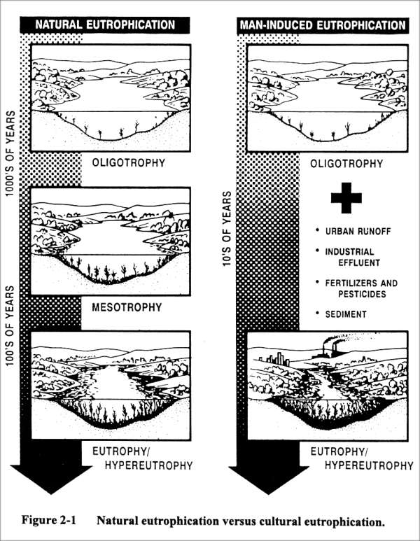
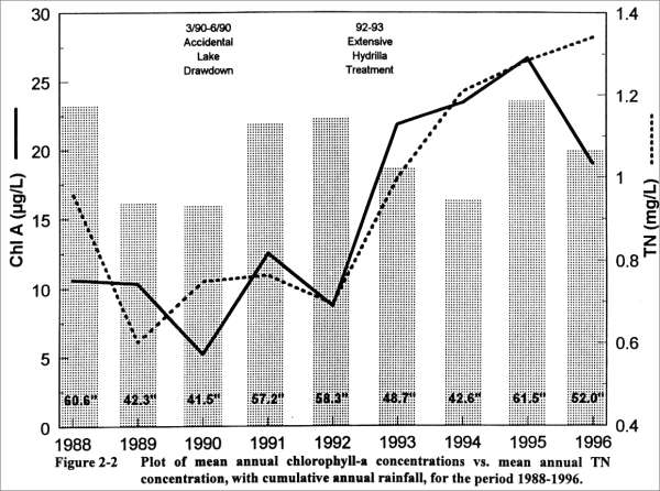
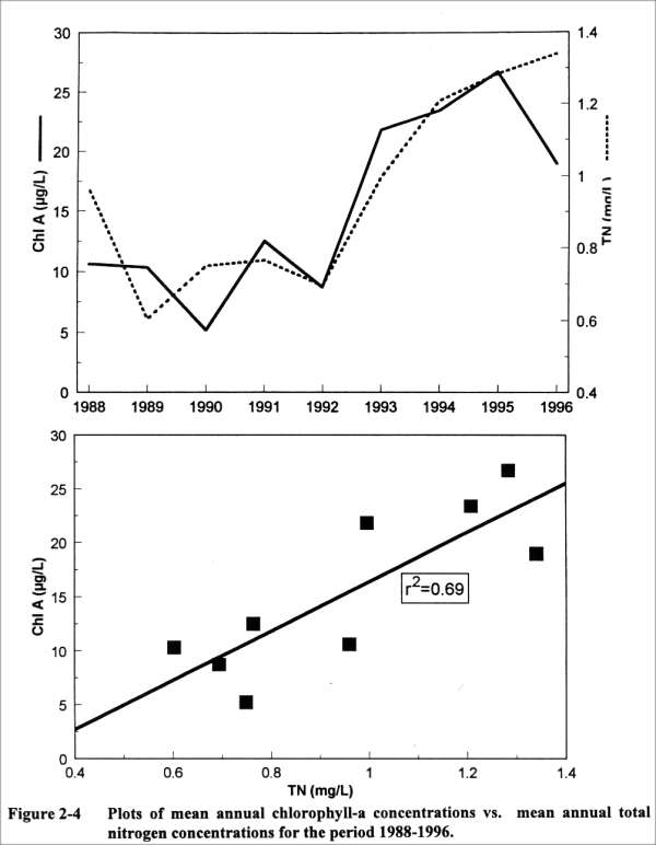
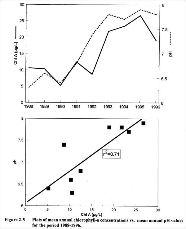
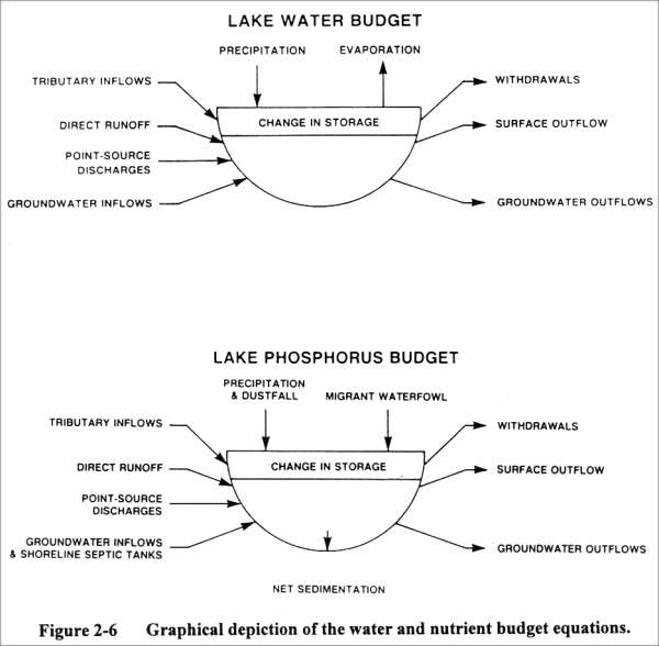
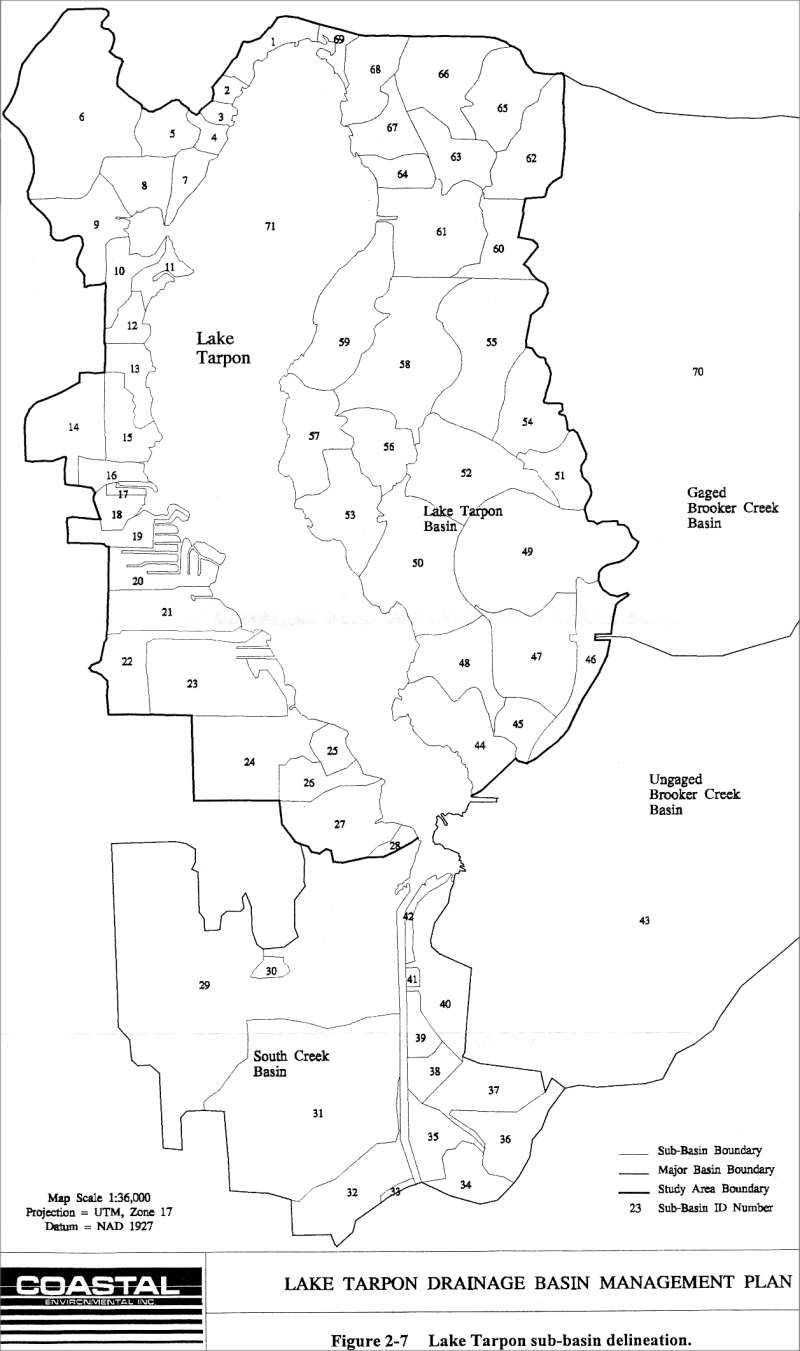
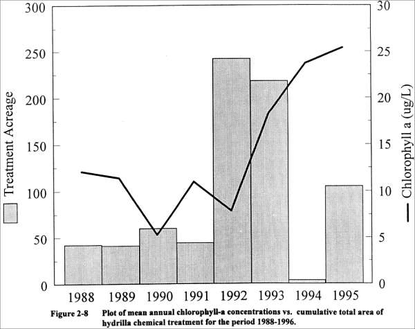
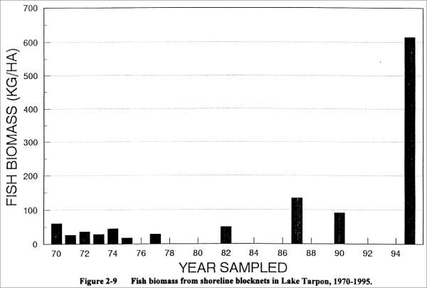
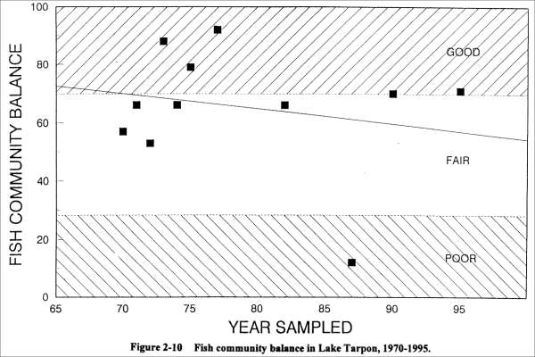
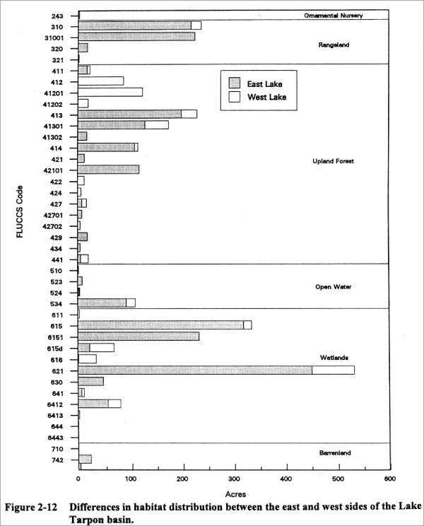
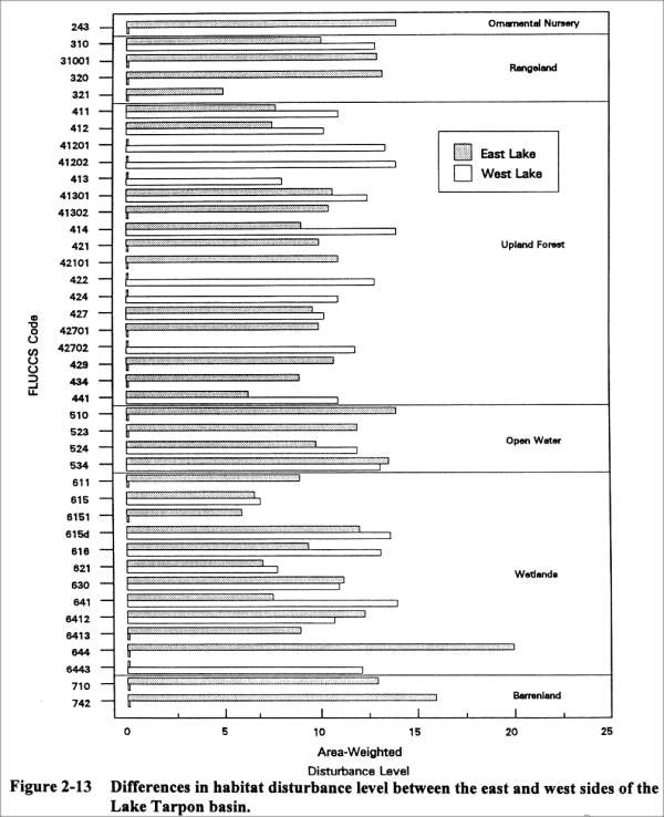